
Make a donation
Gear up for your next adventure:
As an Amazon Associate, this site earns from qualifying purchases at no extra cost to you.
Vale de Telhas topographic map
Click on the map to display elevation.
Make a donation
Gear up for your next adventure:
As an Amazon Associate, this site earns from qualifying purchases at no extra cost to you.
About this map
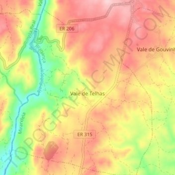
Name: Vale de Telhas topographic map, elevation, terrain.
Location: Vale de Telhas, Mirandela, Distrito de Bragança, Portugal (41.59420 -7.25511 41.64152 -7.20425)
Average elevation: 352 m
Minimum elevation: 236 m
Maximum elevation: 442 m
Make a donation
Gear up for your next adventure:
As an Amazon Associate, this site earns from qualifying purchases at no extra cost to you.
Other topographic maps
Click on a map to view its topography, its elevation and its terrain.
Make a donation
Gear up for your next adventure:
As an Amazon Associate, this site earns from qualifying purchases at no extra cost to you.
Make a donation
Gear up for your next adventure:
As an Amazon Associate, this site earns from qualifying purchases at no extra cost to you.
Vale da Sancha
Portugal > Distrito de Bragança > Mirandela > Frechas > Vale da Sancha
Average elevation: 430 m
Make a donation
Gear up for your next adventure:
As an Amazon Associate, this site earns from qualifying purchases at no extra cost to you.