Geolocate

Juneau topographic map

Click on the map to display elevation.

About this map

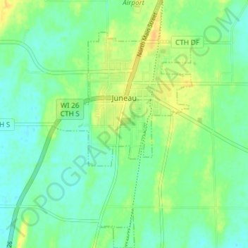
Name: Juneau topographic map, elevation, terrain.

Location: Juneau, Dodge County, Wisconsin, United States (43.37872 -88.72225 43.42281 -88.68852)

Average elevation: 273 m

Minimum elevation: 262 m

Maximum elevation: 289 m

Other topographic maps

Click on a map to view its topography, its elevation and its terrain.

Ashippun

United States > Wisconsin > Dodge County

Average elevation: 272 m

Burnett

United States > Wisconsin > Dodge County

Average elevation: 272 m

Rubicon

United States > Wisconsin > Dodge County

Average elevation: 317 m

Lebanon

United States > Wisconsin > Dodge County

Average elevation: 278 m

Gear up for your next adventure:

🥾Trekking Poles - Adjustable trekking poles to reduce knee stress and improve stability
🥾Trekking Boots - Durable boots for long-distance trekking
Camping Groundsheet - Protect your tent from moisture and dirt
🏃Hydration Running Vest - Carry water and maps close to your body for speed
🛶Kayak Accessories - Essential gear for safe and fun kayaking adventures

As an Amazon Associate, this site earns from qualifying purchases at no extra cost to you.