
Bongará topographic map
Interactive map
Click on the map to display elevation.
About this map
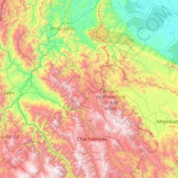
Name: Bongará topographic map, elevation, terrain.
Location: Bongará, Amazonas, Peru (-6.67457 -78.90194 -4.67457 -76.90194)
Average elevation: 1,439 m
Minimum elevation: 124 m
Maximum elevation: 3,957 m
Other topographic maps
Click on a map to view its topography, its elevation and its terrain.
San Cristóbal
Peru > Amazonas > San Cristóbal
San Cristóbal, Luya, Amazonas, Peru
Average elevation: 2,283 m
Pedro Ruiz Gallo
Pedro Ruiz Gallo, Jazán, Bongará, Amazonas, 01130, Peru
Average elevation: 1,598 m