Geolocate

Henagar topographic map

Click on the map to display elevation.

About this map

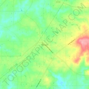
Name: Henagar topographic map, elevation, terrain.

Location: Henagar, DeKalb County, Alabama, 35978, United States (34.59457 -85.79492 34.67593 -85.68893)

Average elevation: 436 m

Minimum elevation: 394 m

Maximum elevation: 514 m

Other topographic maps

Click on a map to view its topography, its elevation and its terrain.

Mentone

United States > Alabama > DeKalb County

Mentone is a town in DeKalb County, Alabama, United States. Mentone, located atop Lookout Mountain, has the highest elevation of any incorporated town in Alabama, and narrowly higher than Hytop.

Average elevation: 470 m

Grove Oak

United States > Alabama > DeKalb County

Average elevation: 344 m

Camp Comer Dam

United States > Alabama > DeKalb County

Average elevation: 490 m

Adamsburg

United States > Alabama > DeKalb County

Average elevation: 423 m

Fort Payne

United States > Alabama > DeKalb County > Fort Payne

Average elevation: 350 m

Red Hill

United States > Alabama > DeKalb County

Average elevation: 255 m

Minvale

United States > Alabama > DeKalb County > Fort Payne > Minvale

Average elevation: 322 m

Gear up for your next adventure:

🧴Outdoor Sunscreen - High SPF protection for high-altitude UV exposure
🕶️Polarized Sunglasses - Reduces glare from snow and water at high elevations
🛶Kayak Dry Bag - Waterproof storage for kayaking adventures
🛌Down Sleeping Bag - Superior warmth-to-weight ratio for cold nights
🥾Light Trekking Boots - Supportive boots for multi-day treks

As an Amazon Associate, this site earns from qualifying purchases at no extra cost to you.