
Make a donation
Gear up for your next adventure:
As an Amazon Associate, this site earns from qualifying purchases at no extra cost to you.
Relva topographic map
Click on the map to display elevation.
Make a donation
Gear up for your next adventure:
As an Amazon Associate, this site earns from qualifying purchases at no extra cost to you.
About this map
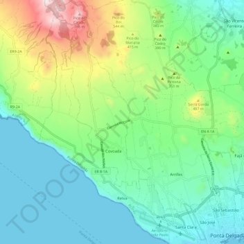
Name: Relva topographic map, elevation, terrain.
Location: Relva, Ponta Delgada, Açores, Portugal (37.73617 -25.75865 37.82698 -25.69633)
Average elevation: 229 m
Minimum elevation: 0 m
Maximum elevation: 855 m
Make a donation
Gear up for your next adventure:
As an Amazon Associate, this site earns from qualifying purchases at no extra cost to you.
Other topographic maps
Click on a map to view its topography, its elevation and its terrain.
Lagoa das Sete Cidades
Insere-se numa área de montanha de relevo bastante acentuado, com falésias interiores, profundas ravinas e almas, e sulcos em cujos leitos correm águas torrenciais. O Pico das Éguas, com 873 metros de altitude, é a maior elevação desta zona, e tem este nome devido às almas que pairam por lá, visto que…
Average elevation: 6 m
Make a donation
Gear up for your next adventure:
As an Amazon Associate, this site earns from qualifying purchases at no extra cost to you.