Geolocate

Hugom topographic map

Click on the map to display elevation.

About this map

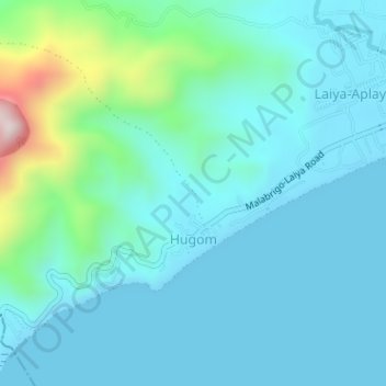
Name: Hugom topographic map, elevation, terrain.

Location: Hugom, San Juan, Batangas, Calabarzon, Philippines (13.65533 121.34411 13.68068 121.37599)

Average elevation: 84 m

Minimum elevation: 0 m

Maximum elevation: 532 m

Other topographic maps

Click on a map to view its topography, its elevation and its terrain.

Malaking Tubig River

Philippines > Batangas > San Juan

Average elevation: 10 m

Ticalan

Philippines > Batangas > San Juan > Ticalan

Average elevation: 8 m

Hugom

Philippines > Batangas > San Juan > Hugom

Average elevation: 76 m

Gear up for your next adventure:

🥘Camping Cookware Set - Compact nesting pots and pans for trail cooking
🛶Waterproof Dry Bags - Keep electronics and clothes dry during river crossings
🧤Insulated Winter Gloves - Heavy-duty protection for sub-zero Canadian adventures
🔋Solar Power Bank - Keep your GPS and devices charged during long outdoor trips
🥾Hiking Gaiters - Protect legs and shoes from mud, snow, and debris

As an Amazon Associate, this site earns from qualifying purchases at no extra cost to you.