Geolocate

Galena topographic map

Click on the map to display elevation.

About this map

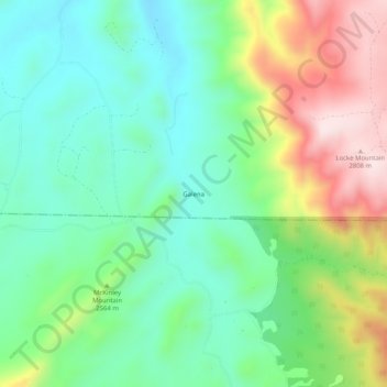
Name: Galena topographic map, elevation, terrain.

Location: Galena, Fremont County, Colorado, United States (38.24195 -105.29777 38.28195 -105.25777)

Average elevation: 2,527 m

Minimum elevation: 2,378 m

Maximum elevation: 2,818 m

Other topographic maps

Click on a map to view its topography, its elevation and its terrain.

Penrose

United States > Colorado > Fremont County

Average elevation: 1,629 m

Coal Creek

United States > Colorado > Fremont County

Average elevation: 1,671 m

Rockvale

United States > Colorado > Fremont County

Average elevation: 1,700 m

Brookside

United States > Colorado > Fremont County

Average elevation: 1,650 m

Gear up for your next adventure:

Backpacking Tent - Lightweight tent for long-distance hiking trips
🥾Waterproof Trail Shoes - Shoes designed to handle wet terrain
🔦LED Headlamp - Hands-free lighting for early morning starts or late finishes
🧥Softshell Jacket - Windproof and breathable jacket for hiking
🥾Mountain Hiking Boots - High-traction boots for rocky terrain

As an Amazon Associate, this site earns from qualifying purchases at no extra cost to you.