Geolocate

Rizal topographic map

Click on the map to display elevation.

About this map

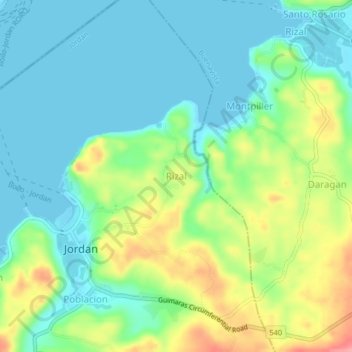
Name: Rizal topographic map, elevation, terrain.

Location: Rizal, Jordan, Guimaras, Western Visayas, Philippines (10.64933 122.58200 10.68933 122.62200)

Average elevation: 30 m

Minimum elevation: -1 m

Maximum elevation: 97 m

Other topographic maps

Click on a map to view its topography, its elevation and its terrain.

Tatlong Pulo Beach

Philippines > Guimaras > Jordan

Average elevation: 9 m

Gear up for your next adventure:

🧴Sunscreen SPF - Broad-spectrum sunscreen for outdoor activities
❄️Traction Ice Cleats - Slip-on spikes for icy trails and winter hiking
🚲Heavy Duty Bike Lock - Secure your bike at the trailhead or during stops
🛶Waterproof Dry Bags - Keep electronics and clothes dry during river crossings
🔭Compact Binoculars - Lightweight optics for scouting trails and wildlife

As an Amazon Associate, this site earns from qualifying purchases at no extra cost to you.