Geolocate

Goirle topographic map

Click on the map to display elevation.

Goirle

Dutch Topographic map of the municipality of Goirle, June 2015

Wikipedia (CC-BY-SA 3.0)

About this map

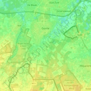
Name: Goirle topographic map, elevation, terrain.

Location: Goirle, North Brabant, Netherlands (51.47111 4.96257 51.54013 5.11065)

Average elevation: 18 m

Minimum elevation: 7 m

Maximum elevation: 28 m

Other topographic maps

Click on a map to view its topography, its elevation and its terrain.

Startwijk

Netherlands > North Brabant > Beugen

Average elevation: 13 m

Gear up for your next adventure:

🥾Trekking Boots - Durable boots for long-distance trekking
🛏️Camping Sleeping Mat - Comfortable mats for sleeping outdoors
🥾Trail Hiking Socks - Comfortable socks to prevent blisters and fatigue
🧰Emergency Multi-Tool - Compact multi-tool for outdoor survival
🥘Camping Cookware Set - Compact nesting pots and pans for trail cooking

As an Amazon Associate, this site earns from qualifying purchases at no extra cost to you.