Geolocate

Vilcas topographic map

Click on the map to display elevation.

About this map

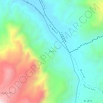
Name: Vilcas topographic map, elevation, terrain.

Location: Vilcas, Sanagorán, Sánchez Carrión, La Libertad, Perú (-7.71572 -78.10829 -7.67572 -78.06829)

Average elevation: 2,533 m

Minimum elevation: 2,231 m

Maximum elevation: 3,226 m

Gear up for your next adventure:

🥾Hiking Shorts - Breathable shorts suitable for summer hikes
🛁Quick-Dry Microfiber Towel - Space-saving towel that dries rapidly on the move
🕶️Polarized Sunglasses - Reduces glare from snow and water at high elevations
🥾Waterproof Hiking Shoes - Durable shoes for wet and rugged trails
🔥Emergency Fire Starter - Reliable ignition source for all weather conditions

As an Amazon Associate, this site earns from qualifying purchases at no extra cost to you.