Geolocate

Crediton topographic map

Click on the map to display elevation.

About this map

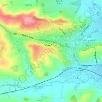
Name: Crediton topographic map, elevation, terrain.

Location: Crediton, Mid Devon, Devon, England, United Kingdom (50.77753 -3.67628 50.79845 -3.63192)

Average elevation: 72 m

Minimum elevation: 36 m

Maximum elevation: 142 m

Gear up for your next adventure:

👟Sport Hiking Sandals - Breathable footwear for water crossings and camp rest
🧥Fleece Jacket - Warm and lightweight jacket for layering
🧰Multitool Knife - Compact and versatile tool for outdoor use
🧊Portable Cooler - Keep food and drinks cold during outdoor adventures
🧣Merino Neck Gaiter - Protects against wind, sun, and cold at high altitudes

As an Amazon Associate, this site earns from qualifying purchases at no extra cost to you.