Geolocate

Binaloan topographic map

Click on the map to display elevation.

About this map

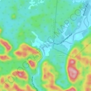
Name: Binaloan topographic map, elevation, terrain.

Location: Binaloan, Eastern Samar, Eastern Visayas, Philippines (11.83430 125.30622 11.87430 125.34622)

Average elevation: 75 m

Minimum elevation: 2 m

Maximum elevation: 239 m

Other topographic maps

Click on a map to view its topography, its elevation and its terrain.

Borongan City

Philippines > Eastern Samar

Average elevation: 11 m

Tikling

Philippines > Eastern Samar

Average elevation: 0 m

Hilabaan

Philippines > Eastern Samar

Average elevation: 1 m

Homonhon Island

Philippines > Eastern Samar > Culasi

Average elevation: 27 m

Calicoan Island

Philippines > Eastern Samar > Ngolos

Average elevation: 4 m

Manicani Island

Philippines > Eastern Samar > Banaag

Average elevation: 18 m

Homonhon Island

Philippines > Eastern Samar > Culasi

Average elevation: 27 m

Jipapad

Philippines > Eastern Samar

Average elevation: 110 m

Suluan Island

Philippines > Eastern Samar > Suluan

Average elevation: 12 m

Homonhon Island

Philippines > Eastern Samar > Habag

Average elevation: 27 m

Oras

Philippines > Eastern Samar > Jipapad

Average elevation: 37 m

Gear up for your next adventure:

🧼Biodegradable Camp Soap - Environmentally friendly cleaning for gear and body
👖Convertible Hiking Pants - Zip-off legs to adapt to changing weather conditions
👟Sport Hiking Sandals - Breathable footwear for water crossings and camp rest
🔥Camping Stove - Portable stoves to cook outdoors with ease
🧳Compression Sacks - Maximize space in your backpack by shrinking gear

As an Amazon Associate, this site earns from qualifying purchases at no extra cost to you.