Geolocate

Policoro topographic map

Click on the map to display elevation.

About this map

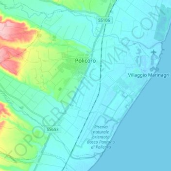
Name: Policoro topographic map, elevation, terrain.

Location: Policoro, Matera, Basilicata, 75025, Italy (40.14818 16.59884 40.24152 16.73775)

Average elevation: 20 m

Minimum elevation: -3 m

Maximum elevation: 144 m

Gear up for your next adventure:

🛰️Satellite Messenger - Emergency communication for areas with no cell service
🚲MTB Frame Bag - Carry tools and maps directly on your bicycle frame
🪑Insulated Seat Pad - Protect your seat from cold rocks and wet logs
🛶Canoe Life Vest - Safety vest for water sports
Lightweight Backpacking Tent - Compact tent for efficient hiking trips

As an Amazon Associate, this site earns from qualifying purchases at no extra cost to you.