Geolocate

Fritzlar topographic map

Click on the map to display elevation.

About this map

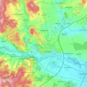
Name: Fritzlar topographic map, elevation, terrain.

Location: Fritzlar, Schwalm-Eder-Kreis, Hesse, 34560, Germany (51.08369 9.18667 51.20051 9.36912)

Average elevation: 237 m

Minimum elevation: 160 m

Maximum elevation: 416 m

Gear up for your next adventure:

🥫Freeze-Dried Meals - Lightweight, high-calorie nutrition for multi-day treks
🧴Outdoor Sunscreen - High SPF protection for high-altitude UV exposure
🧦Hiking Liner Socks - Thin base layer to prevent friction and blisters
🧴Bear Spray Holster - Quick-access carry for essential Canadian wilderness safety
🧴Insect Repellent - Protect yourself from bugs during outdoor adventures

As an Amazon Associate, this site earns from qualifying purchases at no extra cost to you.