Geolocate

Samanga topographic map

Click on the map to display elevation.

About this map

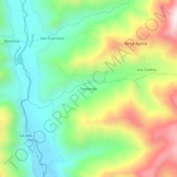
Name: Samanga topographic map, elevation, terrain.

Location: Samanga, Colasay, Jaén, Cajamarca, Perú (-5.79004 -79.04282 -5.75004 -79.00282)

Average elevation: 1,348 m

Minimum elevation: 1,071 m

Maximum elevation: 1,815 m

Other topographic maps

Click on a map to view its topography, its elevation and its terrain.

Río Huancabamba

Perú > Cajamarca > Colasay

Average elevation: 934 m

Gear up for your next adventure:

🧢Beanie Hat - Keep your head warm in cold weather
🥾Hiking Boots - Sturdy boots providing ankle support and traction on rugged trails
🧼Travel Hand Sanitizer - Keep hands clean when water is scarce
🥾Trail Running Shoes - Lightweight and durable shoes for trail running
🛌Insulated Sleeping Pad - Critical thermal barrier between you and the cold ground

As an Amazon Associate, this site earns from qualifying purchases at no extra cost to you.