
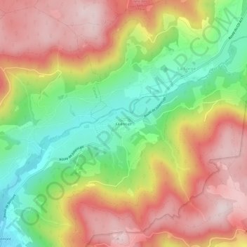
Julienrupt topographic map
Interactive map
Click on the map to display elevation.
About this map
Name: Julienrupt topographic map, elevation, terrain.
Average elevation: 636 m
Minimum elevation: 431 m
Maximum elevation: 830 m
Other topographic maps
Click on a map to view its topography, its elevation and its terrain.
À l'Omet
France > Grand Est > Vosges > Le Syndicat
À l'Omet, Les Mézés, Le Syndicat, Saint-Dié-des-Vosges, Vosges, Grand Est, France métropolitaine, 88120, France
Average elevation: 584 m
Hameau de Bréhavillers
France > Grand Est > Vosges > Le Syndicat
Hameau de Bréhavillers, Le Syndicat, Saint-Dié-des-Vosges, Vosges, Grand Est, France métropolitaine, 88120, France
Average elevation: 483 m
Bémont
France > Grand Est > Vosges > Le Syndicat
Bémont, Le Syndicat, Saint-Dié-des-Vosges, Vosges, Grand Est, France métropolitaine, 88120, France
Average elevation: 524 m