
Make a donation
Gear up for your next adventure:
As an Amazon Associate, this site earns from qualifying purchases at no extra cost to you.
Bobadela topographic map
Click on the map to display elevation.
Make a donation
Gear up for your next adventure:
As an Amazon Associate, this site earns from qualifying purchases at no extra cost to you.
Bobadela
The Chapel of São Lourenço, erected in 1742, is located in the higher altitudes of the settlement, and since this period has fallen on a bad state of conservation.
Make a donation
Gear up for your next adventure:
As an Amazon Associate, this site earns from qualifying purchases at no extra cost to you.
About this map
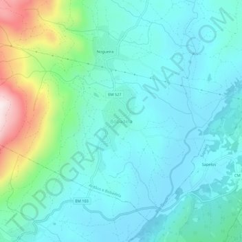
Name: Bobadela topographic map, elevation, terrain.
Location: Bobadela, Boticas, Vila Real, Portugal (41.71104 -7.63805 41.75104 -7.59805)
Average elevation: 633 m
Minimum elevation: 506 m
Maximum elevation: 1,126 m
Make a donation
Gear up for your next adventure:
As an Amazon Associate, this site earns from qualifying purchases at no extra cost to you.
Other topographic maps
Click on a map to view its topography, its elevation and its terrain.