
Make a donation
Gear up for your next adventure:
As an Amazon Associate, this site earns from qualifying purchases at no extra cost to you.
Glungezer topographic map
Click on the map to display elevation.
Make a donation
Gear up for your next adventure:
As an Amazon Associate, this site earns from qualifying purchases at no extra cost to you.
Glungezer
Der Gipfel des Glungezer hat eine Höhe von 2677 Meter über dem Meeresspiegel. Damit überragt er den benachbarten und viel bekannteren Patscherkofel um über 400 Meter. Von Innsbruck aus ist allerdings nur die Sonnenspitze (2639 m), ein ca. 500 m nordwestlich vorgelagerter Nebengipfel zu sehen. Das Glungezer-Gipfelkreuz befindet sich etwa 70 m nördlich seines Gipfels.
Make a donation
Gear up for your next adventure:
As an Amazon Associate, this site earns from qualifying purchases at no extra cost to you.
About this map
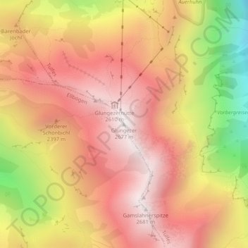
Name: Glungezer topographic map, elevation, terrain.
Location: Glungezer, Tulfes, Bezirk Innsbruck-Land, Tirol, Österreich (47.20755 11.52833 47.20765 11.52843)
Average elevation: 2,242 m
Minimum elevation: 1,522 m
Maximum elevation: 2,670 m
Make a donation
Gear up for your next adventure:
As an Amazon Associate, this site earns from qualifying purchases at no extra cost to you.