
Make a donation
Gear up for your next adventure:
As an Amazon Associate, this site earns from qualifying purchases at no extra cost to you.
IGHREM topographic map
Click on the map to display elevation.
Make a donation
Gear up for your next adventure:
As an Amazon Associate, this site earns from qualifying purchases at no extra cost to you.
About this map
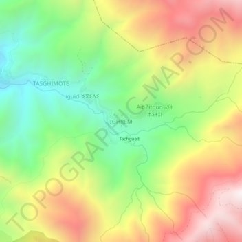
Name: IGHREM topographic map, elevation, terrain.
Average elevation: 1,839 m
Minimum elevation: 1,289 m
Maximum elevation: 2,484 m
Make a donation
Gear up for your next adventure:
As an Amazon Associate, this site earns from qualifying purchases at no extra cost to you.
Other topographic maps
Click on a map to view its topography, its elevation and its terrain.
Ijoukak
Maroc > Marrakech-Safi > Cercle d'Asni
Ijoukak est situé dans le Haut Atlas sur la route (R 203) qui relie Marrakech à Taroudant par le col du Tizi N'Test, dans la haute vallée de l'oued N'Fiss, affluent de l'oued Tensift, à une altitude d'environ 1200 m. L'oued Agoundis, descendu du flanc sud du djebel Toubkal, s'y jette dans le N'Fiss, en…
Average elevation: 1,910 m
Ijoukak
Maroc > Marrakech-Safi > Cercle d'Asni
Ijoukak est situé dans le Haut Atlas sur la route (R 203) qui relie Marrakech à Taroudant par le col du Tizi N'Test, dans la haute vallée de l'oued N'Fiss, affluent de l'oued Tensift, à une altitude d'environ 1200 m. L'oued Agoundis, descendu du flanc sud du djebel Toubkal, s'y jette dans le N'Fiss, en…
Average elevation: 1,901 m
Make a donation
Gear up for your next adventure:
As an Amazon Associate, this site earns from qualifying purchases at no extra cost to you.
Kasbah Talat n'Yacoub
Maroc > Marrakech-Safi > Cercle d'Asni > Tikiout > Talat-n-Ya’qoub
Average elevation: 1,310 m