Geolocate

Datal Bila topographic map

Click on the map to display elevation.

About this map

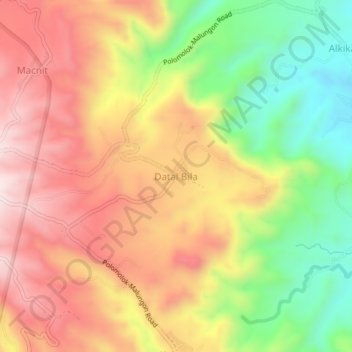
Name: Datal Bila topographic map, elevation, terrain.

Location: Datal Bila, Malungon, Sarangani, Philippines (6.34194 125.11904 6.38194 125.15904)

Average elevation: 790 m

Minimum elevation: 521 m

Maximum elevation: 1,021 m

Other topographic maps

Click on a map to view its topography, its elevation and its terrain.

Buayan River

Philippines > Sarangani > Malungon

Average elevation: 149 m

Gear up for your next adventure:

🔥Camping Stove - Portable stoves to cook outdoors with ease
Camping Essentials - All-in-one gear for a comfortable camping trip
🥾Lightweight Hiking Boots - Boots for comfort and mobility on long hikes
🌡️Emergency Mylar Blankets - Compact thermal protection for unexpected nights outdoors
Lightweight Camping Tent - Portable shelter optimized for Canadian backcountry camping

As an Amazon Associate, this site earns from qualifying purchases at no extra cost to you.