
Make a donation
Gear up for your next adventure:
As an Amazon Associate, this site earns from qualifying purchases at no extra cost to you.
Camacha topographic map
Click on the map to display elevation.
Make a donation
Gear up for your next adventure:
As an Amazon Associate, this site earns from qualifying purchases at no extra cost to you.
Camacha
Localiza-se a uma latitude 32.7 (32°42') Norte e a uma longitude 16,84 (16°49'20") Oeste, estando a uma altitude de aproximadamente 700 metros. Camacha tem uma estrada que liga Funchal e Santo António da Serra. A atividade principal é a agricultura. Situada no interior da Ilha da Madeira, possui uma área montanhosa a norte.
Make a donation
Gear up for your next adventure:
As an Amazon Associate, this site earns from qualifying purchases at no extra cost to you.
About this map
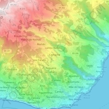
Name: Camacha topographic map, elevation, terrain.
Location: Camacha, Santa Cruz, Madeira, 9135-053, Portugal (32.63944 -16.88487 32.71944 -16.80487)
Average elevation: 548 m
Minimum elevation: 0 m
Maximum elevation: 1,420 m
Make a donation
Gear up for your next adventure:
As an Amazon Associate, this site earns from qualifying purchases at no extra cost to you.
Other topographic maps
Click on a map to view its topography, its elevation and its terrain.
Camacha
A Vila da Camacha é uma freguesia portuguesa do concelho de Santa Cruz, com 19,58 km² de área e 7 449 habitantes (2011). A sua densidade populacional é 380,4 hab/km². Localiza-se a uma latitude 32.7 (32°42') Norte e a uma longitude 16,84 (16°49'20") Oeste, estando a uma altitude de aproximadamente 700…
Average elevation: 722 m
Make a donation
Gear up for your next adventure:
As an Amazon Associate, this site earns from qualifying purchases at no extra cost to you.