
Make a donation
Gear up for your next adventure:
As an Amazon Associate, this site earns from qualifying purchases at no extra cost to you.
Wasserauen topographic map
Click on the map to display elevation.
Make a donation
Gear up for your next adventure:
As an Amazon Associate, this site earns from qualifying purchases at no extra cost to you.
About this map
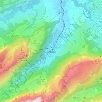
Name: Wasserauen topographic map, elevation, terrain.
Average elevation: 1,185 m
Minimum elevation: 831 m
Maximum elevation: 1,904 m
Make a donation
Gear up for your next adventure:
As an Amazon Associate, this site earns from qualifying purchases at no extra cost to you.
Other topographic maps
Click on a map to view its topography, its elevation and its terrain.
Seealpsee
Switzerland > Appenzell Innerrhoden > Schwende-Rüte
Seealpsee is a lake in the Alpstein range of the canton of Appenzell Innerrhoden, Switzerland. At an elevation of 1,143.2 m, the surface area is 13.6 hectares (34 acres). The lake can be reached by foot from Wasserauen or from Ebenalp. It is a popular tourist destination. A network of routes around Ebenalp…
Average elevation: 1,491 m