Make a donation
Gear up for your next adventure:
As an Amazon Associate, this site earns from qualifying purchases at no extra cost to you.
Abrego topographic map
Click on the map to display elevation.
Make a donation
Gear up for your next adventure:
As an Amazon Associate, this site earns from qualifying purchases at no extra cost to you.
Abrego
Ábrego (Spanish pronunciation: [ˈaβɾeɣo]) is a Colombian municipality and town located in the department of Norte de Santander. The urban centre is situated at an altitude of 1,398 metres (4,587 ft) in the Eastern Ranges of the Colombian Andes.
Make a donation
Gear up for your next adventure:
As an Amazon Associate, this site earns from qualifying purchases at no extra cost to you.
About this map
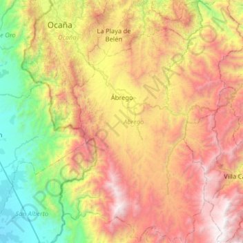
Name: Abrego topographic map, elevation, terrain.
Average elevation: 1,557 m
Minimum elevation: 64 m
Maximum elevation: 3,583 m
Make a donation
Gear up for your next adventure:
As an Amazon Associate, this site earns from qualifying purchases at no extra cost to you.
Other topographic maps
Click on a map to view its topography, its elevation and its terrain.
Villa del Rosario
Colombia > Norte de Santander > Villa del Rosario > Villa del Rosario
Average elevation: 437 m
Make a donation
Gear up for your next adventure:
As an Amazon Associate, this site earns from qualifying purchases at no extra cost to you.
