Geolocate

Cikembar topographic map

Click on the map to display elevation.

About this map

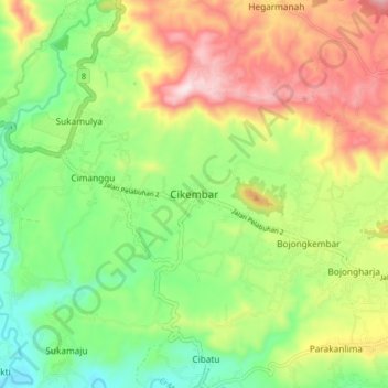
Name: Cikembar topographic map, elevation, terrain.

Location: Cikembar, Sukabumi, West Java, Java, Indonesia (-7.00204 106.75573 -6.92204 106.83573)

Average elevation: 364 m

Minimum elevation: 186 m

Maximum elevation: 611 m

Gear up for your next adventure:

🧥Waterproof Jacket - Lightweight rain jackets for hiking and outdoor activities
🔦LED Flashlight - Powerful and long-lasting flashlight for camping and emergencies
Camping Groundsheet - Protect your tent from moisture and dirt
🌬️Windproof Camp Stove - Efficient cooking even on exposed mountain peaks
🧢Sun Hat - Wide-brim hat for sun protection

As an Amazon Associate, this site earns from qualifying purchases at no extra cost to you.