Geolocate

Kembangbahu topographic map

Click on the map to display elevation.

About this map

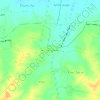
Name: Kembangbahu topographic map, elevation, terrain.

Location: Kembangbahu, Lamongan, East Java, Java, 62283, Indonesia (-7.20395 112.32989 -7.16395 112.36989)

Average elevation: 25 m

Minimum elevation: 10 m

Maximum elevation: 49 m

Other topographic maps

Click on a map to view its topography, its elevation and its terrain.

Sidokumpul

Indonesia > East Java > Lamongan > Sambeng

Average elevation: 74 m

Gondang Dam

Indonesia > East Java > Lamongan > Deketagung

Average elevation: 39 m

Lamongan

Indonesia > East Java > Lamongan

Average elevation: 30 m

Gear up for your next adventure:

🧢Outdoor Visor - Breathable visor for sunny hikes
🥫Freeze-Dried Meals - Lightweight, high-calorie nutrition for multi-day treks
💧Reusable Water Bottle - Durable water bottles for hydration on trails
💧Hydration Bladder - Hands-free hydration solution for long treks
🥾Durable Hiking Shoes - Long-lasting shoes for frequent hiking

As an Amazon Associate, this site earns from qualifying purchases at no extra cost to you.