Make a donation
Gear up for your next adventure:
As an Amazon Associate, this site earns from qualifying purchases at no extra cost to you.
Seyssins topographic map
Click on the map to display elevation.
Make a donation
Gear up for your next adventure:
As an Amazon Associate, this site earns from qualifying purchases at no extra cost to you.
About this map
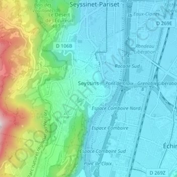
Name: Seyssins topographic map, elevation, terrain.
Average elevation: 366 m
Minimum elevation: 214 m
Maximum elevation: 1,009 m
Make a donation
Gear up for your next adventure:
As an Amazon Associate, this site earns from qualifying purchases at no extra cost to you.
Other topographic maps
Click on a map to view its topography, its elevation and its terrain.
Make a donation
Gear up for your next adventure:
As an Amazon Associate, this site earns from qualifying purchases at no extra cost to you.
Le Col de l'Arzelier
France > Auvergne-Rhône-Alpes > Isère > Château-Bernard
Average elevation: 1,206 m
MontGaren
France > Auvergne-Rhône-Alpes > Isère > La Chapelle-du-Bard > MontGaren
Average elevation: 651 m
Make a donation
Gear up for your next adventure:
As an Amazon Associate, this site earns from qualifying purchases at no extra cost to you.
Make a donation
Gear up for your next adventure:
As an Amazon Associate, this site earns from qualifying purchases at no extra cost to you.
Les Gaudes
France > Auvergne-Rhône-Alpes > Isère > Saint-Pierre-de-Chartreuse
Average elevation: 1,062 m
Make a donation
Gear up for your next adventure:
As an Amazon Associate, this site earns from qualifying purchases at no extra cost to you.
Make a donation
Gear up for your next adventure:
As an Amazon Associate, this site earns from qualifying purchases at no extra cost to you.
Le Désert en Valjouffrey
France > Auvergne-Rhône-Alpes > Isère > Valjouffrey
Average elevation: 1,815 m
