
Make a donation
Gear up for your next adventure:
As an Amazon Associate, this site earns from qualifying purchases at no extra cost to you.
Bekkevoort topographic map
Click on the map to display elevation.
Make a donation
Gear up for your next adventure:
As an Amazon Associate, this site earns from qualifying purchases at no extra cost to you.
Bekkevoort
Bekkevoort is een plaats en gemeente in de Belgische provincie Vlaams-Brabant. De gemeente telt ruim 6.000 inwoners en ligt op een hoogte van 64 meter.
Make a donation
Gear up for your next adventure:
As an Amazon Associate, this site earns from qualifying purchases at no extra cost to you.
About this map
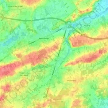
Name: Bekkevoort topographic map, elevation, terrain.
Location: Bekkevoort, Leuven, Vlaams-Brabant, 3460, België (50.89946 4.93352 50.96844 5.02015)
Average elevation: 53 m
Minimum elevation: 23 m
Maximum elevation: 86 m
Make a donation
Gear up for your next adventure:
As an Amazon Associate, this site earns from qualifying purchases at no extra cost to you.