Geolocate

Lembor topographic map

Click on the map to display elevation.

About this map

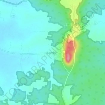
Name: Lembor topographic map, elevation, terrain.

Location: Lembor, Lamongan, East Java, Java, Indonesia (-6.94745 112.21228 -6.90745 112.25228)

Average elevation: 29 m

Minimum elevation: 4 m

Maximum elevation: 131 m

Other topographic maps

Click on a map to view its topography, its elevation and its terrain.

Bluluk

Indonesia > East Java > Lamongan

Average elevation: 73 m

Sukorame

Indonesia > East Java > Lamongan

Average elevation: 101 m

Jejel

Indonesia > East Java > Lamongan > Ngimbang

Average elevation: 80 m

Wonorejo

Indonesia > East Java > Lamongan > Sambeng

Average elevation: 81 m

Ngimbang

Indonesia > East Java > Lamongan

Average elevation: 89 m

Pamotan

Indonesia > East Java > Lamongan > Sambeng

Average elevation: 78 m

Garung

Indonesia > East Java > Lamongan > Sambeng

Average elevation: 76 m

Sambeng

Indonesia > East Java > Lamongan

Average elevation: 79 m

Pataan

Indonesia > East Java > Lamongan > Sambeng

Average elevation: 102 m

Selorejo

Indonesia > East Java > Lamongan > Sambeng

Average elevation: 55 m

Gear up for your next adventure:

🔭Outdoor Binoculars - Lightweight binoculars for birdwatching and hiking
👟Trail Running Shoes - Agile footwear for fast-paced topographic exploration
🧢Hiking Hat - Sun-protective and breathable hats for long treks
🔥Camping Stove - Portable stoves to cook outdoors with ease
🥾Hiking Boots - Sturdy boots providing ankle support and traction on rugged trails

As an Amazon Associate, this site earns from qualifying purchases at no extra cost to you.