Geolocate

Ambrunes topographic map

Click on the map to display elevation.

About this map

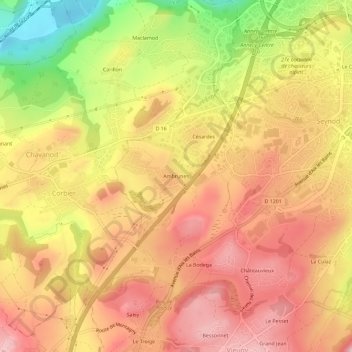
Name: Ambrunes topographic map, elevation, terrain.

Location: Ambrunes, Seynod, Annecy, Haute-Savoie, Auvergne-Rhône-Alpes, France métropolitaine, 74600, France (45.86177 6.05440 45.90177 6.09440)

Average elevation: 528 m

Minimum elevation: 379 m

Maximum elevation: 621 m

Other topographic maps

Click on a map to view its topography, its elevation and its terrain.

74600

France > Auvergne-Rhône-Alpes > Haute-Savoie > Annecy > Seynod > Mathonex

Average elevation: 675 m

Gear up for your next adventure:

🔦LED Headlamp - Hands-free lighting for early morning starts or late finishes
🥾Trail Hiking Shoes - Durable shoes designed for rugged trails
🏃Hydration Running Vest - Carry water and maps close to your body for speed
Lightweight Backpacking Tent - Compact tent for efficient hiking trips
🔪Outdoor Multitool - Versatile tool for repairs and food prep in the wild

As an Amazon Associate, this site earns from qualifying purchases at no extra cost to you.