Geolocate

Cuntis topographic map

Click on the map to display elevation.

About this map

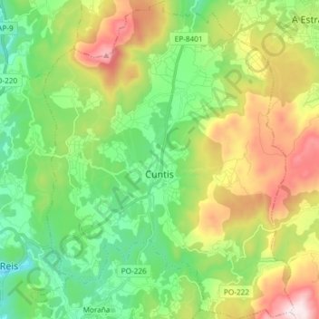
Name: Cuntis topographic map, elevation, terrain.

Location: Cuntis, Caldas, Pontevedra, Galicia, España (42.58595 -8.61598 42.69439 -8.49965)

Average elevation: 298 m

Minimum elevation: 23 m

Maximum elevation: 798 m

Other topographic maps

Click on a map to view its topography, its elevation and its terrain.

Vilar de Mato

España > Galicia > Caldas > Cuntis

Average elevation: 411 m

Fervenza de Segade

España > Galicia > Caldas > Caldas de Reis

Average elevation: 137 m

Vilameán

España > Galicia > Caldas > Cuntis

Average elevation: 225 m

Marán

España > Galicia > Caldas > Caldas de Reis

Average elevation: 93 m

Mesego

España > Galicia > Caldas > Cuntis

Average elevation: 405 m

Arcos da Condesa

España > Galicia > Caldas > Caldas de Reis

Average elevation: 103 m

Os Barreiros

España > Galicia > Caldas > Caldas de Reis

Average elevation: 86 m

Gear up for your next adventure:

🧢Outdoor Visor - Breathable visor for sunny hikes
🥾Hiking Shoes - Durable and comfortable shoes for trail hiking
💧Hydration Pack - Hands-free hydration system for long hikes
Family Camping Tent - Spacious tent suitable for family camping trips
🧴Sunscreen SPF - Broad-spectrum sunscreen for outdoor activities

As an Amazon Associate, this site earns from qualifying purchases at no extra cost to you.