
Pohangina topographic map
Click on the map to display elevation.
Pohangina
Pohangina is located along the foot of the Ruahine Range, and is primarily farming land. Farming varies from sheep and cattle to crops of maize and 'chow'. The farmland was originally ancient native forest. Rimu and northern rātā grew above 1000 feet, with kamahi, kaikawaka and pink pine growing at higher and steeper slopes, leatherwood scrub growing at higher altitudes, and wild tussocks growing at the summits of the range.
About this map
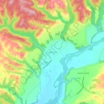
Name: Pohangina topographic map, elevation, terrain.
Average elevation: 190 m
Minimum elevation: 104 m
Maximum elevation: 313 m
Other topographic maps
Click on a map to view its topography, its elevation and its terrain.
Kitchener Park
New Zealand > Manawatu-Whanganui > Manawatū District > Feilding
Average elevation: 63 m