Geolocate

Pala topographic map

Click on the map to display elevation.

Pala

The community is in the Pacific time zone. Pala is at an altitude of 404 feet, located at 33°21′55″N 117°04′36″W / 33.36528°N 117.07667°W / 33.36528; -117.07667 (latitude 33.365N, longitude 117.075W).

Wikipedia (CC-BY-SA 3.0)

About this map

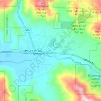
Name: Pala topographic map, elevation, terrain.

Location: Pala, San Diego County, California, 92059, United States (33.34649 -117.09937 33.38448 -117.03764)

Average elevation: 245 m

Minimum elevation: 105 m

Maximum elevation: 641 m

Gear up for your next adventure:

👟Sport Hiking Sandals - Breathable footwear for water crossings and camp rest
🥾Lightweight Hiking Shoes - Comfortable shoes for day hikes
🏕️Camping Hammock - Integrated protection for sleeping between trees
🚲Heavy Duty Bike Lock - Secure your bike at the trailhead or during stops
🗺️Topographic Maps - Detailed maps to explore trails, mountains, and wilderness areas

As an Amazon Associate, this site earns from qualifying purchases at no extra cost to you.