Geolocate

Maresana topographic map

Click on the map to display elevation.

About this map

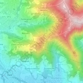
Name: Maresana topographic map, elevation, terrain.

Location: Maresana, Ponteranica, Bergamo, Lombardia, 24010, Italia (45.73051 9.67526 45.73061 9.67536)

Average elevation: 432 m

Minimum elevation: 277 m

Maximum elevation: 703 m

Gear up for your next adventure:

💧Hydration Pack - Hands-free hydration system for long hikes
🛰️Satellite Messenger - Emergency communication for areas with no cell service
🧥Softshell Jacket - Windproof and breathable jacket for hiking
🦌Outdoor Trail Camera - Monitor wildlife activity near your favorite spots
🥾Mountain Trail Shoes - High-traction shoes for mountain trails

As an Amazon Associate, this site earns from qualifying purchases at no extra cost to you.