
Make a donation
Gear up for your next adventure:
As an Amazon Associate, this site earns from qualifying purchases at no extra cost to you.
Asama topographic map
Click on the map to display elevation.
Make a donation
Gear up for your next adventure:
As an Amazon Associate, this site earns from qualifying purchases at no extra cost to you.
Asama
Der Asama liegt etwas östlich des Kurofu, eines aus Andesit aufgebauten Vulkans, der vor rund 20.000 Jahren durch einen Erdrutsch zerstört wurde. Anschließend entstand ein Schildvulkan aus Dazit; er war insbesondere vor 11.000 bis 14.000 Jahren Ausgangspunkt von pyroklastischen Strömen. Zur gleichen Zeit entstand der Lavadom Ko-Asama, der rund drei Kilometer östlich des heutigen Gipfels liegt. Alle Eruptionen in historischer Zeit gingen vom Maekake aus, der wahrscheinlich ein Alter von wenigen tausend Jahren hat. Dem Maekake aufgesetzt ist der Koma, ein pyroklastischer Kegel, der mit einer Höhe von 2568 Metern der Gipfel des Vulkans ist.
Make a donation
Gear up for your next adventure:
As an Amazon Associate, this site earns from qualifying purchases at no extra cost to you.
About this map
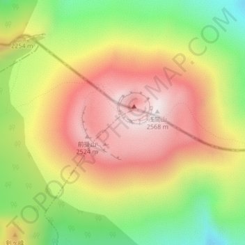
Name: Asama topographic map, elevation, terrain.
Location: Asama, 嬬恋村, 吾妻郡, Präfektur Gunma, Japan (36.40650 138.52290 36.40660 138.52300)
Average elevation: 2,158 m
Minimum elevation: 1,640 m
Maximum elevation: 2,563 m
Make a donation
Gear up for your next adventure:
As an Amazon Associate, this site earns from qualifying purchases at no extra cost to you.