
English Harbour topographic map
Interactive map
Click on the map to display elevation.
About this map
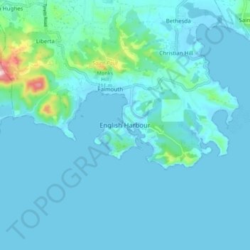
Name: English Harbour topographic map, elevation, terrain.
Location: English Harbour, Saint Paul, Antigua, Antigua and Barbuda (16.97182 -61.80844 17.05182 -61.72844)
Average elevation: 29 m
Minimum elevation: -5 m
Maximum elevation: 324 m
Other topographic maps
Click on a map to view its topography, its elevation and its terrain.
St. John's
St. John's, Saint John, Antigua, Antigua and Barbuda
Average elevation: 23 m