Geolocate

Laja topographic map

Click on the map to display elevation.

About this map

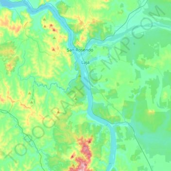
Name: Laja topographic map, elevation, terrain.

Location: Laja, Provincia de Bío-Bío, Biobio Region, Chile (-37.39604 -72.73026 -37.22872 -72.43208)

Average elevation: 113 m

Minimum elevation: 27 m

Maximum elevation: 441 m

Other topographic maps

Click on a map to view its topography, its elevation and its terrain.

Polcura

Chile > Biobío Region > Provincia de Bío-Bío > Tucapel

Average elevation: 585 m

Gear up for your next adventure:

🧦Hiking Socks - Moisture-wicking and comfortable socks for long hikes
🧢Sun Protection Cap - Breathable cap to protect from sun exposure
💡Solar Camping Lamp - Eco-friendly lighting for campsites
🥾Trail Hiking Shoes - Durable shoes designed for rugged trails
🧥Waterproof Hiking Jacket - Protect yourself from rain and wind while hiking

As an Amazon Associate, this site earns from qualifying purchases at no extra cost to you.