Geolocate

Montauban topographic map

Click on the map to display elevation.

About this map
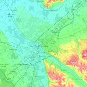
Name: Montauban topographic map, elevation, terrain.

Location: Montauban, Tarn-et-Garonne, Occitania, Metropolitan France, 82000, France (43.95126 1.28654 44.09221 1.44279)

Average elevation: 104 m

Minimum elevation: 71 m

Maximum elevation: 215 m

Other topographic maps

Click on a map to view its topography, its elevation and its terrain.
La Nauze

France > Occitania > Tarn-et-Garonne > Molières > Molières

Average elevation: 140 m

Lac Doux

France > Occitania > Tarn-et-Garonne > Loze > Mas d'Estèbe

Average elevation: 329 m

Badio

France > Occitania > Tarn-et-Garonne > Castelferrus

Average elevation: 101 m

Gear up for your next adventure:

🕶️Polarized Sunglasses - Reduces glare from snow and water at high elevations
⛺Backpacking Tent - Lightweight tent for long-distance hiking trips
🥤Collapsible Travel Cup - Saves space and weight in your mess kit
🧥Softshell Jacket - Windproof and breathable jacket for hiking
🛰️Satellite Messenger - Emergency communication for areas with no cell service

As an Amazon Associate, this site earns from qualifying purchases at no extra cost to you.