
La Bruyère topographic map
Interactive map
Click on the map to display elevation.
About this map
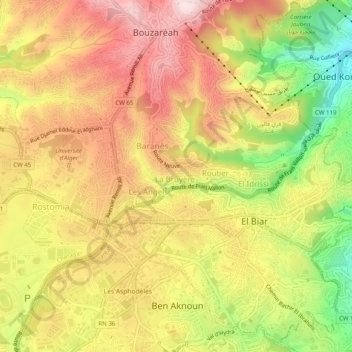
Name: La Bruyère topographic map, elevation, terrain.
Location: La Bruyère, Bouzaréah, Daïra Bouzareah, Alger, 16340, Algérie (36.75369 2.99935 36.79369 3.03935)
Average elevation: 247 m
Minimum elevation: 48 m
Maximum elevation: 399 m
Other topographic maps
Click on a map to view its topography, its elevation and its terrain.
Les Angels
Algérie > Alger > Daïra Bouzareah > Bouzaréah
Les Angels, Bouzaréah, Daïra Bouzareah, Alger, 16340, Algérie
Average elevation: 253 m