
Make a donation
Gear up for your next adventure:
As an Amazon Associate, this site earns from qualifying purchases at no extra cost to you.
Kaçkar Dağı topographic map
Click on the map to display elevation.
Make a donation
Gear up for your next adventure:
As an Amazon Associate, this site earns from qualifying purchases at no extra cost to you.
Kaçkar Dağı
Mount Kaçkar (Turkish: Kaçkar Dağı), with an elevation of 3,937 meters, is the highest peak in the Kaçkar Mountains. The mountain may be climbed by the northeast ridge route beginning from the village Yukarı Kavrun.
Make a donation
Gear up for your next adventure:
As an Amazon Associate, this site earns from qualifying purchases at no extra cost to you.
About this map
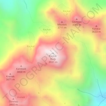
Name: Kaçkar Dağı topographic map, elevation, terrain.
Location: Kaçkar Dağı, Yusufeli, Artvin, Black Sea Region, Turkey (40.83542 41.16127 40.83552 41.16137)
Average elevation: 3,388 m
Minimum elevation: 2,760 m
Maximum elevation: 3,912 m
Make a donation
Gear up for your next adventure:
As an Amazon Associate, this site earns from qualifying purchases at no extra cost to you.