Geolocate

Centro II topographic map

Click on the map to display elevation.

About this map

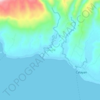
Name: Centro II topographic map, elevation, terrain.

Location: Centro II, Calayan, Cagayan, Cagayan Valley, Philippines (19.25016 121.44241 19.29016 121.48241)

Average elevation: 50 m

Minimum elevation: 0 m

Maximum elevation: 319 m

Other topographic maps

Click on a map to view its topography, its elevation and its terrain.

Babuyan Island

Philippines > Cagayan > Calayan

Average elevation: 185 m

Sibang Cove

Philippines > Cagayan > Calayan > Dadao

Average elevation: 56 m

Babuyan Island

Philippines > Cagayan > Calayan

Average elevation: 185 m

Gear up for your next adventure:

🥾Hiking Shorts - Breathable shorts suitable for summer hikes
🚲MTB Frame Bag - Carry tools and maps directly on your bicycle frame
🧣Evaporative Cooling Towel - Beat the heat during intense summer climbs
👖Convertible Hiking Pants - Zip-off legs to adapt to changing weather conditions
👟Leg Gaiters - Keep debris, mud, and snow out of your boots

As an Amazon Associate, this site earns from qualifying purchases at no extra cost to you.