
Aciera topographic map
Interactive map
Click on the map to display elevation.
About this map
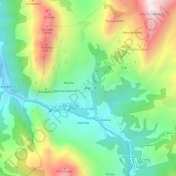
Name: Aciera topographic map, elevation, terrain.
Location: Aciera, Quirós, Asturias, 33118, España (43.18411 -6.02772 43.22411 -5.98772)
Average elevation: 663 m
Minimum elevation: 271 m
Maximum elevation: 1,334 m
Other topographic maps
Click on a map to view its topography, its elevation and its terrain.
San Vicente de Nimbra
San Vicente de Nimbra, Quirós, Asturias, 33116, España
Average elevation: 860 m
Villaorille
España > Asturias > Quirós > Villaorille
Villaorille, Quirós, Asturias, 33118, España
Average elevation: 633 m
Parque Natural de Las Ubiñas-La Mesa
Parque Natural de Las Ubiñas-La Mesa, QU-3, Quirós, Asturias, 33116, España
Average elevation: 1,116 m