
Make a donation
Gear up for your next adventure:
As an Amazon Associate, this site earns from qualifying purchases at no extra cost to you.
Sfax topographic map
Click on the map to display elevation.
Make a donation
Gear up for your next adventure:
As an Amazon Associate, this site earns from qualifying purchases at no extra cost to you.
Sfax
The topography of the governorate of Sfax tilts regularly from the west to the coast and local presents small hills and mountain ranges in the form of elongated draâs.
Make a donation
Gear up for your next adventure:
As an Amazon Associate, this site earns from qualifying purchases at no extra cost to you.
About this map
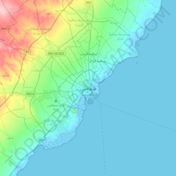
Name: Sfax topographic map, elevation, terrain.
Location: Sfax, المدينة, معتمدية صفاقس المدينة, Sfax, 3000, Tunisia (34.57944 10.60040 34.89944 10.92040)
Average elevation: 24 m
Minimum elevation: -4 m
Maximum elevation: 148 m
Make a donation
Gear up for your next adventure:
As an Amazon Associate, this site earns from qualifying purchases at no extra cost to you.