
Make a donation
Gear up for your next adventure:
As an Amazon Associate, this site earns from qualifying purchases at no extra cost to you.
Karacahisar topographic map
Click on the map to display elevation.
Make a donation
Gear up for your next adventure:
As an Amazon Associate, this site earns from qualifying purchases at no extra cost to you.
Karacahisar
The village is located at a distance of 22 km (14 mi) to the district center of Milas and 91 km (57 mi) to the province center of Muğla. Its elevation is 150 m (490 ft) AMSL.
Make a donation
Gear up for your next adventure:
As an Amazon Associate, this site earns from qualifying purchases at no extra cost to you.
About this map
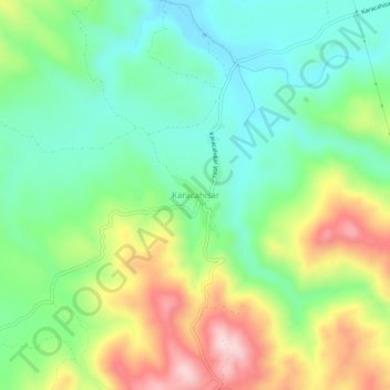
Name: Karacahisar topographic map, elevation, terrain.
Location: Karacahisar, Milas, Muğla, Aegean Region, Turkey (37.13056 27.78453 37.17056 27.82453)
Average elevation: 222 m
Minimum elevation: 107 m
Maximum elevation: 427 m
Make a donation
Gear up for your next adventure:
As an Amazon Associate, this site earns from qualifying purchases at no extra cost to you.