
Thank you for supporting this site ❤️
Make a donation
Make a donation
Gear up for your next adventure:
As an Amazon Associate, this site earns from qualifying purchases at no extra cost to you.
Besease topographic map
Click on the map to display elevation.
Thank you for supporting this site ❤️
Make a donation
Make a donation
Gear up for your next adventure:
As an Amazon Associate, this site earns from qualifying purchases at no extra cost to you.
About this map
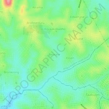
Name: Besease topographic map, elevation, terrain.
Location: Besease, Afigya-Kwabre South District, Ashanti Region, Ghana (6.75902 -1.64297 6.79902 -1.60297)
Average elevation: 279 m
Minimum elevation: 244 m
Maximum elevation: 353 m
Thank you for supporting this site ❤️
Make a donation
Make a donation
Gear up for your next adventure:
As an Amazon Associate, this site earns from qualifying purchases at no extra cost to you.