Geolocate

Babahoyo topographic map

Click on the map to display elevation.

About this map

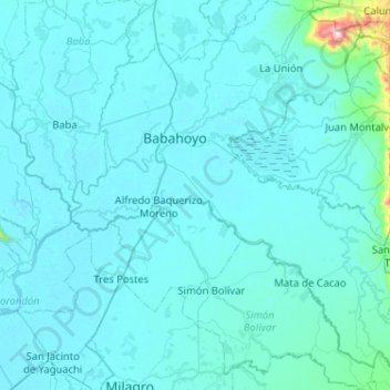
Name: Babahoyo topographic map, elevation, terrain.

Location: Babahoyo, Los Ríos, Ecuador (-2.13305 -79.67147 -1.61968 -79.18858)

Average elevation: 30 m

Minimum elevation: -1 m

Maximum elevation: 806 m

Other topographic maps

Click on a map to view its topography, its elevation and its terrain.

Los Cedros

Ecuador > Los Ríos > Vinces > Vinces

Average elevation: 25 m

Pepa De Oro

Ecuador > Los Ríos > Puebloviejo > Puebloviejo

Average elevation: 14 m

La Fortuna

Ecuador > Los Ríos > Quinsaloma > Quinsaloma

Average elevation: 94 m

Sam Augustin

Ecuador > Los Ríos > Valencia > Valencia

Average elevation: 103 m

Patria Nueva

Ecuador > Los Ríos > Vinces > Vinces

Average elevation: 16 m

Galapagos

Ecuador > Los Ríos > Mocache > Mocache > Galapagos

Average elevation: 59 m

Gear up for your next adventure:

🧥Waterproof Jacket - Lightweight rain jackets for hiking and outdoor activities
🦌Outdoor Trail Camera - Monitor wildlife activity near your favorite spots
🧭Orienteering Kit - Tools for map reading and navigation in the wild
👟Sport Hiking Sandals - Breathable footwear for water crossings and camp rest
🚲Bike Repair Kit - Essential tools for on-trail mechanical issues

As an Amazon Associate, this site earns from qualifying purchases at no extra cost to you.