
Make a donation
Gear up for your next adventure:
As an Amazon Associate, this site earns from qualifying purchases at no extra cost to you.
Nikoi Island topographic map
Click on the map to display elevation.
Make a donation
Gear up for your next adventure:
As an Amazon Associate, this site earns from qualifying purchases at no extra cost to you.
About this map
Name: Nikoi Island topographic map, elevation, terrain.
Location: Nikoi Island, Bintan, Riau Islands, Sumatra, Indonesia (0.73190 104.38959 1.37190 105.02959)
Average elevation: 3 m
Minimum elevation: -4 m
Maximum elevation: 314 m
Make a donation
Gear up for your next adventure:
As an Amazon Associate, this site earns from qualifying purchases at no extra cost to you.
Other topographic maps
Click on a map to view its topography, its elevation and its terrain.
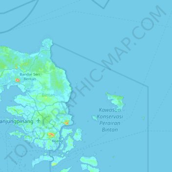
Bintan Island
Indonesia > Riau Islands > Bintan
Bintan, is the largest among the 3,200 islands of Riau Archipelago and is located 10 kilometres (6.2 mi) east of the Batam Island. It has a coast line of 105 kilometres (65 mi) and has rolling topography in its landform. The Riau Islands are a province of Indonesia, which encompassed the Riau Archipelago,…
Average elevation: 6 m