Geolocate

Naga topographic map

Click on the map to display elevation.

About this map

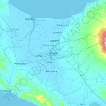
Name: Naga topographic map, elevation, terrain.

Location: Naga, Camarines Sur, Bicol Region, 4400, Philippines (13.46401 123.02503 13.78401 123.34503)

Average elevation: 51 m

Minimum elevation: -2 m

Maximum elevation: 905 m

Gear up for your next adventure:

🧦Hiking Socks - Moisture-wicking and comfortable socks for long hikes
🥾Trail Running Boots - Durable shoes designed for trail running
🧥Waterproof Hiking Jacket - Protect yourself from rain and wind while hiking
🔋Lithium AA Batteries - Long-lasting power that performs in extreme cold
🥾Waterproof Trail Shoes - Shoes designed to handle wet terrain

As an Amazon Associate, this site earns from qualifying purchases at no extra cost to you.