Geolocate

Rawis topographic map

Click on the map to display elevation.

About this map

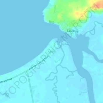
Name: Rawis topographic map, elevation, terrain.

Location: Rawis, Northern Samar, Eastern Visayas, 6411, Philippines (12.54065 124.98686 12.58065 125.02686)

Average elevation: 4 m

Minimum elevation: -3 m

Maximum elevation: 40 m

Other topographic maps

Click on a map to view its topography, its elevation and its terrain.

Catarman

Philippines > Northern Samar

Average elevation: 50 m

Biri

Philippines > Northern Samar

Average elevation: 1 m

Catubig River

Philippines > Northern Samar

Average elevation: 38 m

Sitio Rabbit

Philippines > Northern Samar > Victoria

Average elevation: 27 m

Tarnate

Philippines > Northern Samar > San Vicente

Average elevation: 27 m

Capul Island

Philippines > Northern Samar > Capul

Average elevation: 14 m

Capul

Philippines > Northern Samar

Average elevation: 5 m

Palanit

Philippines > Northern Samar

Average elevation: 52 m

Capul Island

Philippines > Northern Samar > Capul

Average elevation: 14 m

Catarman

Philippines > Northern Samar

Average elevation: 51 m

Catarman

Philippines > Northern Samar

Average elevation: 51 m

Gear up for your next adventure:

🏕️Camping Hammock - Integrated protection for sleeping between trees
🥾All-Terrain Hiking Boots - Versatile boots for varied hiking conditions
Lightweight Backpacking Tent - Compact tent for efficient hiking trips
🚲Heavy Duty Bike Lock - Secure your bike at the trailhead or during stops
🕶️Polarized Sunglasses - Protect your eyes with durable polarized lenses

As an Amazon Associate, this site earns from qualifying purchases at no extra cost to you.