
Gravel Spring topographic map
Click on the map to display elevation.
About this map
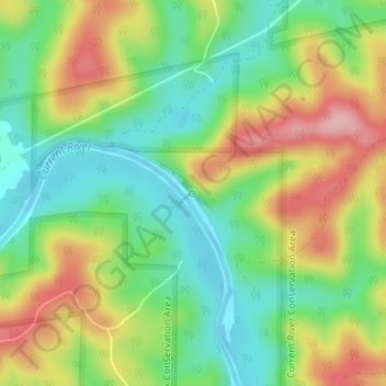
Name: Gravel Spring topographic map, elevation, terrain.
Average elevation: 210 m
Minimum elevation: 147 m
Maximum elevation: 297 m
Other topographic maps
Click on a map to view its topography, its elevation and its terrain.
Eminence
United States > Missouri > Shannon County
A post office called Eminence has been in operation since 1844. According to one account, Eminence was so named on account of its lofty elevation, however, this interpretation is disputed.
Average elevation: 221 m
Eminence
United States > Missouri > Shannon County
A post office called Eminence has been in operation since 1844. According to one account, Eminence was so named on account of its lofty elevation, however, this interpretation is disputed.
Average elevation: 221 m
Eminence
United States > Missouri > Shannon County
A post office called Eminence has been in operation since 1844. According to one account, Eminence was so named on account of its lofty elevation, however, this interpretation is disputed.
Average elevation: 221 m