
Thank you for supporting this site ❤️
Make a donation
Make a donation
Gear up for your next adventure:
As an Amazon Associate, this site earns from qualifying purchases at no extra cost to you.
Katungulu topographic map
Click on the map to display elevation.
Thank you for supporting this site ❤️
Make a donation
Make a donation
Gear up for your next adventure:
As an Amazon Associate, this site earns from qualifying purchases at no extra cost to you.
About this map
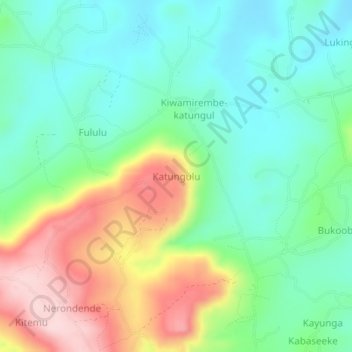
Name: Katungulu topographic map, elevation, terrain.
Location: Katungulu, Mityana, Central Region, Uganda (0.54667 32.06333 0.58667 32.10333)
Average elevation: 1,212 m
Minimum elevation: 1,120 m
Maximum elevation: 1,388 m
Thank you for supporting this site ❤️
Make a donation
Make a donation
Gear up for your next adventure:
As an Amazon Associate, this site earns from qualifying purchases at no extra cost to you.